Property Record
Keith Bridge Rd, Gainesville, GA 30506

NEARBY LISTINGS FOR SALE OR LEASE
-
-
View all Gainesville listings for sale on LoopNet.com
Property Detail
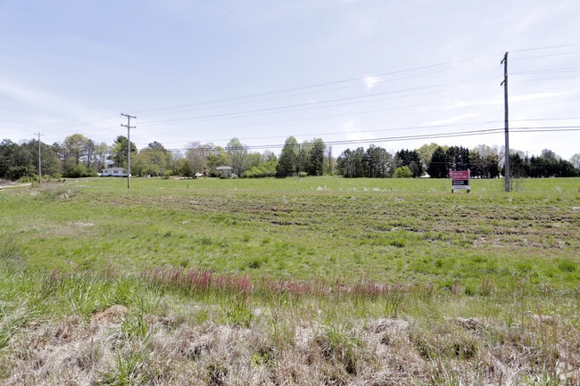
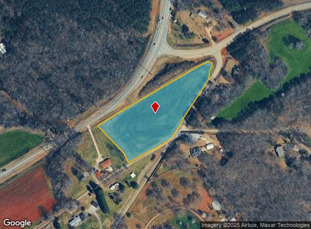
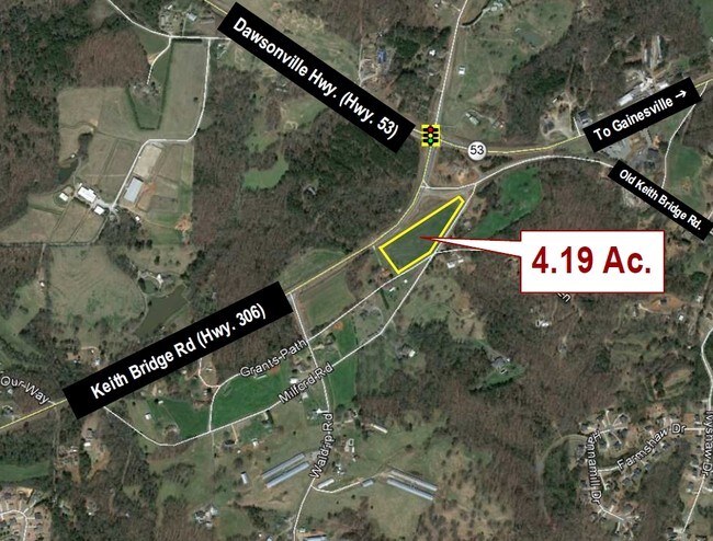
Keith Bridge Rd
Atlanta-Sandy Springs-Roswell, GA
Whistlestop
302-019
14-1 1197 LTS 3-5 WHISTLE STOP&OTHR LND
Agriculturalland
Forsyth
X
Georgia
13139C0175G
3-5
2024
4.19 AC
2025
N Fulton/Forsyth County
000307
Atlanta
DEMOGRAPHICS near Keith Bridge Rd
1 Mile
3 Mile
5 Mile
2024 Total Population
1,669
13,968
39,867
2029 Population
1,954
16,456
47,074
Pop Growth 2024-2029
+ 17.08%
+ 17.81%
+ 18.08%
Average Age
41
41
42
2024 Total Households
598
4,931
14,547
HH Growth 2024-2029
+ 17.22%
+ 17.91%
+ 18.21%
Median Household Inc
$95,277
$94,215
$94,577
Avg Household Size
2.80
2.80
2.70
2024 Avg HH Vehicles
3.00
3.00
2.00
Median Home Value
$418,627
$426,660
$436,246
Median Year Built
2000
2000
1998
Nearby Places
Map Layers
Map Styles
 Street
 Aerial
- Restaurants
- Banks
- Shops
- Fitness
- Groceries
SALE & LEASE HISTORY
LISTING DATE
SALE/LEASE

Sep 24, 2016
For Sale
Nov 23, 2016
For Sale
Nearby Properties
Address
Land Use
TOTAL SIZE
Lot Size
Zoning
Address
Land Use
TOTAL SIZE
Lot Size
Zoning
250,371 SF
88.47 AC
A1
Address
Land Use
TOTAL SIZE
Lot Size
Zoning
66,824 SF
11 AC
A1
Address
Land Use
TOTAL SIZE
Lot Size
Zoning
5,253 SF
84.12 AC
A1
Address
Land Use
TOTAL SIZE
Lot Size
Zoning
1,364 SF
69.09 AC
A1
Address
Land Use
TOTAL SIZE
Lot Size
Zoning
79.21 AC
A1
Address
Land Use
TOTAL SIZE
Lot Size
Zoning
3,779 SF
16.17 AC
A1
Address
Land Use
TOTAL SIZE
Lot Size
Zoning
14.69 AC
RES2
Address
Land Use
TOTAL SIZE
Lot Size
Zoning
6,016 SF
19.10 AC
A1
Address
Land Use
TOTAL SIZE
Lot Size
Zoning
7,771 SF
22.31 AC
A1
Address
Land Use
TOTAL SIZE
Lot Size
Zoning
5,681 SF
26.23 AC
A1
Address
Land Use
TOTAL SIZE
Lot Size
Zoning
1,626 SF
34.79 AC
A1
Address
Land Use
TOTAL SIZE
Lot Size
Zoning
14,967 SF
15.30 AC
CBD
Address
Land Use
TOTAL SIZE
Lot Size
Zoning
8,125 SF
2.07 AC
NS
Address
Land Use
TOTAL SIZE
Lot Size
Zoning
5,046 SF
6.08 AC
A1
Address
Land Use
TOTAL SIZE
Lot Size
Zoning
3,924 SF
13.41 AC
A1
Address
Land Use
TOTAL SIZE
Lot Size
Zoning
3,358 SF
A1
Address
Land Use
TOTAL SIZE
Lot Size
Zoning
4,478 SF
2.60 AC
A1
Address
Land Use
TOTAL SIZE
Lot Size
Zoning
4,911 SF
10.01 AC
A1
Address
Land Use
TOTAL SIZE
Lot Size
Zoning
3,297 SF
10.02 AC
A1
Address
Land Use
TOTAL SIZE
Lot Size
Zoning
2,132 SF
20.64 AC
A1
Address
Land Use
TOTAL SIZE
Lot Size
Zoning
2,739 SF
10.61 AC
A1
Address
Land Use
TOTAL SIZE
Lot Size
Zoning
13,470 SF
2.30 AC
HB
Address
Land Use
TOTAL SIZE
Lot Size
Zoning
1,920 SF
3.09 AC
A1
Address
Land Use
TOTAL SIZE
Lot Size
Zoning
2,923 SF
5.16 AC
A1
Address
Land Use
TOTAL SIZE
Lot Size
Zoning
1,784 SF
15.75 AC
A1
Address
Land Use
TOTAL SIZE
Lot Size
Zoning
4,618 SF
5.50 AC
A1
Address
Land Use
TOTAL SIZE
Lot Size
Zoning
2,743 SF
11.99 AC
A1
Address
Land Use
TOTAL SIZE
Lot Size
Zoning
0.23 AC
A1
Address
Land Use
TOTAL SIZE
Lot Size
Zoning
3,516 SF
16.93 AC
A1
Address
Land Use
TOTAL SIZE
Lot Size
Zoning
3,317 SF
1.01 AC
A1
The World's #1 Commercial Real Estate Marketplace
Connect with us
© 2025 CoStar Group
The information above has been obtained from sources believed reliable. While we do not doubt its accuracy we have not verified it and make no guarantee, warranty or representation about it. It is your responsibility to independently confirm its accuracy and completeness. Any projections, opinions, assumptions, or estimates used are for example only and do not represent the current or future performance of the property. The value of this transaction to you depends on tax and other factors which should be evaluated by your tax, financial, and legal advisors. You and your advisors should conduct a careful, independent investigation of the property to determine to your satisfaction the suitability of the property for your needs.